What alternatives to NUKEMAP3D exist?
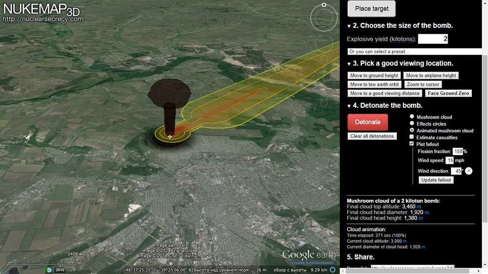
At the moment, the only easy alternative is to use the NUKEMAP’s experimental KMZ output option. To use it, set up any detonation(s) you want to view in 3D in NUKEMAP, and then, click on «Advanced Options»:
Scroll down to the end of the «Advanced Options» and you’ll find a link that says «Export to KMZ»:
Clicking that opens up the «Export to KMZ» options. There are a lot of options but you probably just want to leave the default ones and click «Download File.» But you’re welcome to experiment with the other options if it doesn’t look the way you’d like it to, or you want it to show fallout or the fireball. Once you’ve download the KMZ file (named nukemap.kmz by default), you can then open it in the free Google Earth Pro desktop application:
As noted, this functionality is still experimental. It does not always reliably export fallout plumes, for example. And the Google Earth desktop application does not render buildings at the same distance as the plugin did, so it doesn’t quite give the same effect. Note that once it is in Google Earth Pro, you can toggle off the various components of the model as «layers» in the sidebar.
What did NUKEMAP3D do and look like?
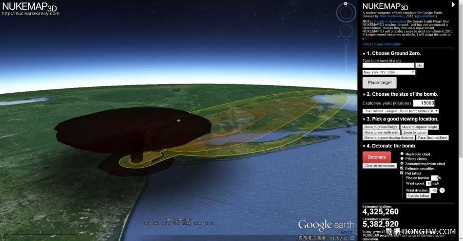
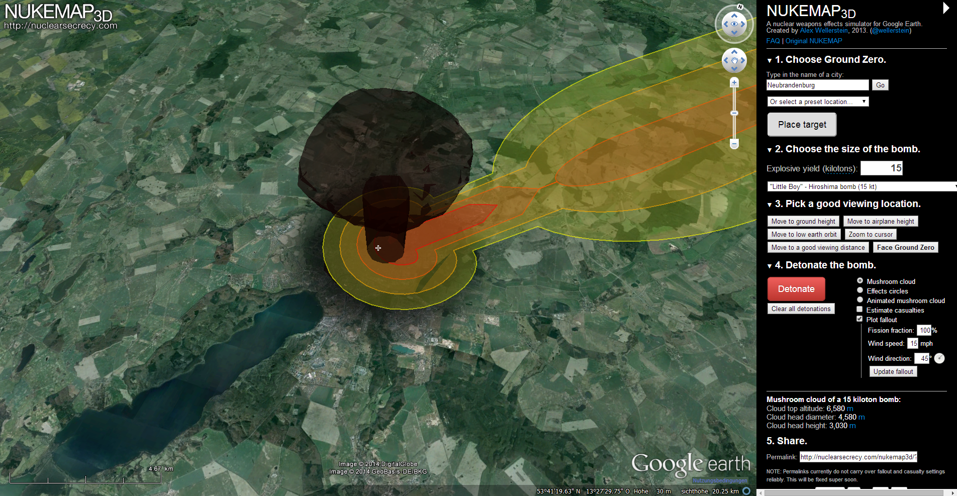
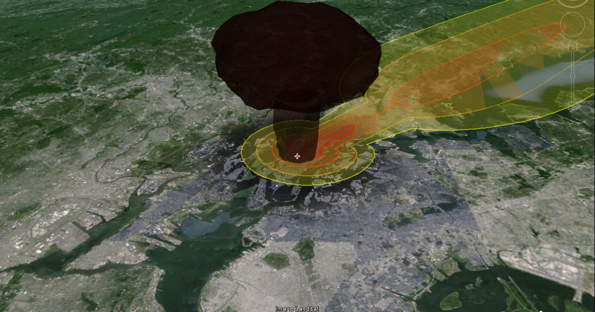
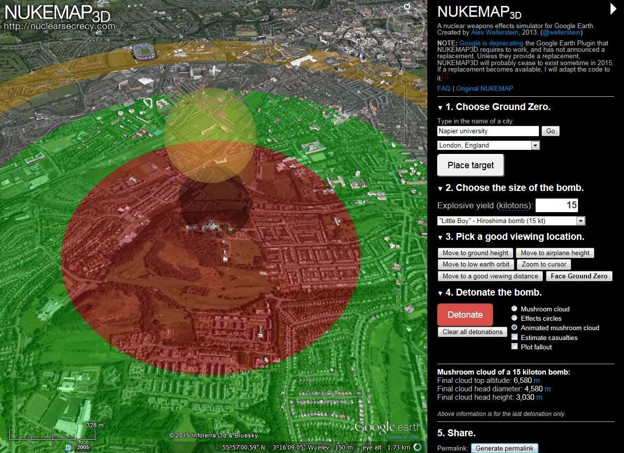
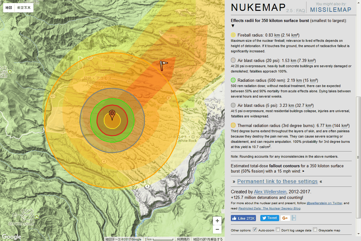
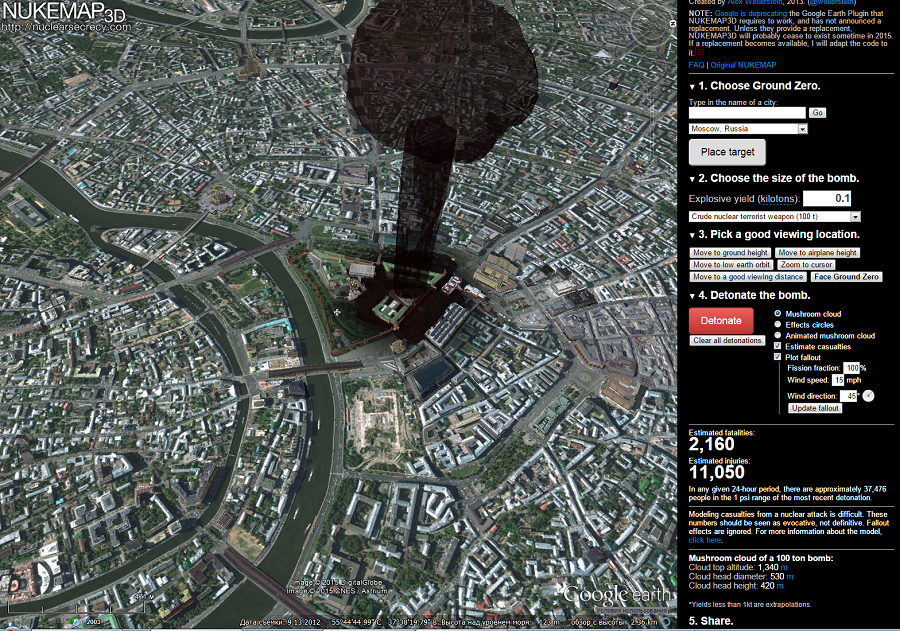
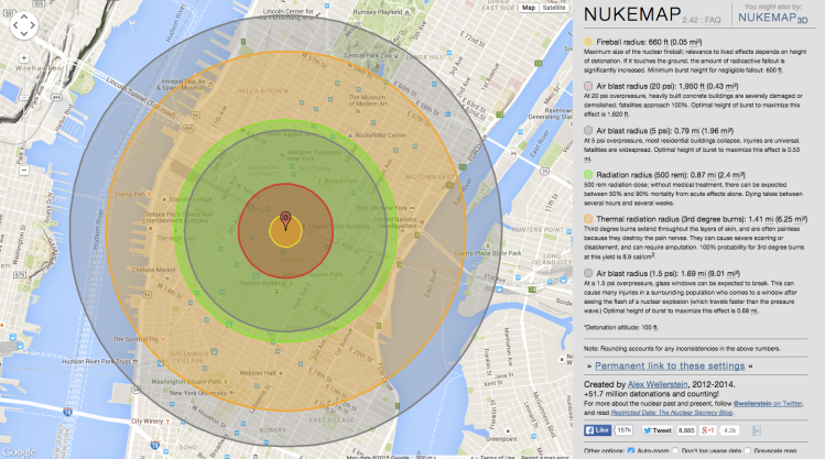
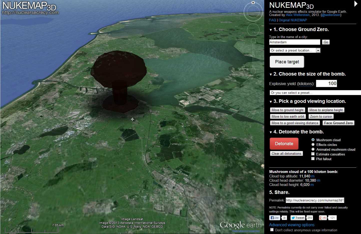
NUKEMAP3D was a mashup between the NUKEMAP and the Google Earth Browser Plugin, created by Alex Wellerstein in 2013. It allowed a user to see the ground effects of a nuclear weapon over any city in the world in 3D, as well as render a size-accurate mushroom cloud for any given yield of nuclear weapon. The goal was to help give a human understanding of nuclear weapons detonations: everyone has seen photographs of nuclear mushroom clouds, but few people have any sense of how large they actually are. Even a «small» nuclear weapon (by modern standards), like those used over the cities of Hiroshima and Nagasaki, is many times larger than anything human beings have ever built. By engaging the third dimension, something more intuitive triggers in the brain, even more so than the 2D representations possible in the original NUKEMAP.
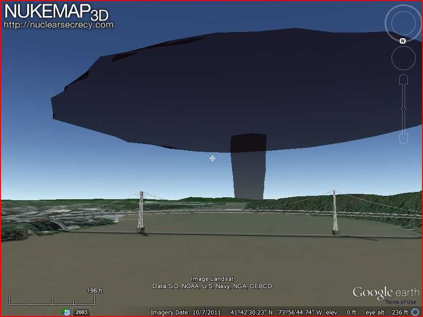
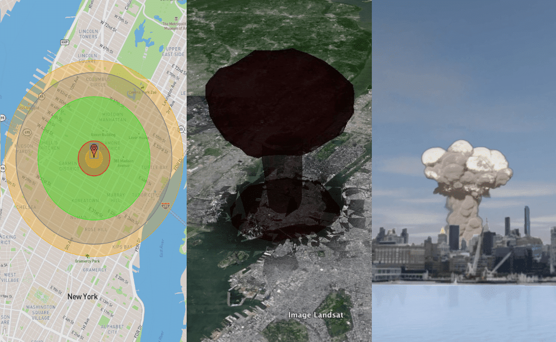
Some screenshots from NUKEMAP3D have been preserved (click to see full-sized):
| 20 kilotons on Manhattan, viewed airplane height | 20 kilotons on mid-town Manhattan, as viewed from nearer to the surface, with the Statue of Liberty and downtown Manhattan for scale | 20 kilotons on Manhattan (animated GIF; you could have the cloud rise in real-time, which would take about 10 minutes) |
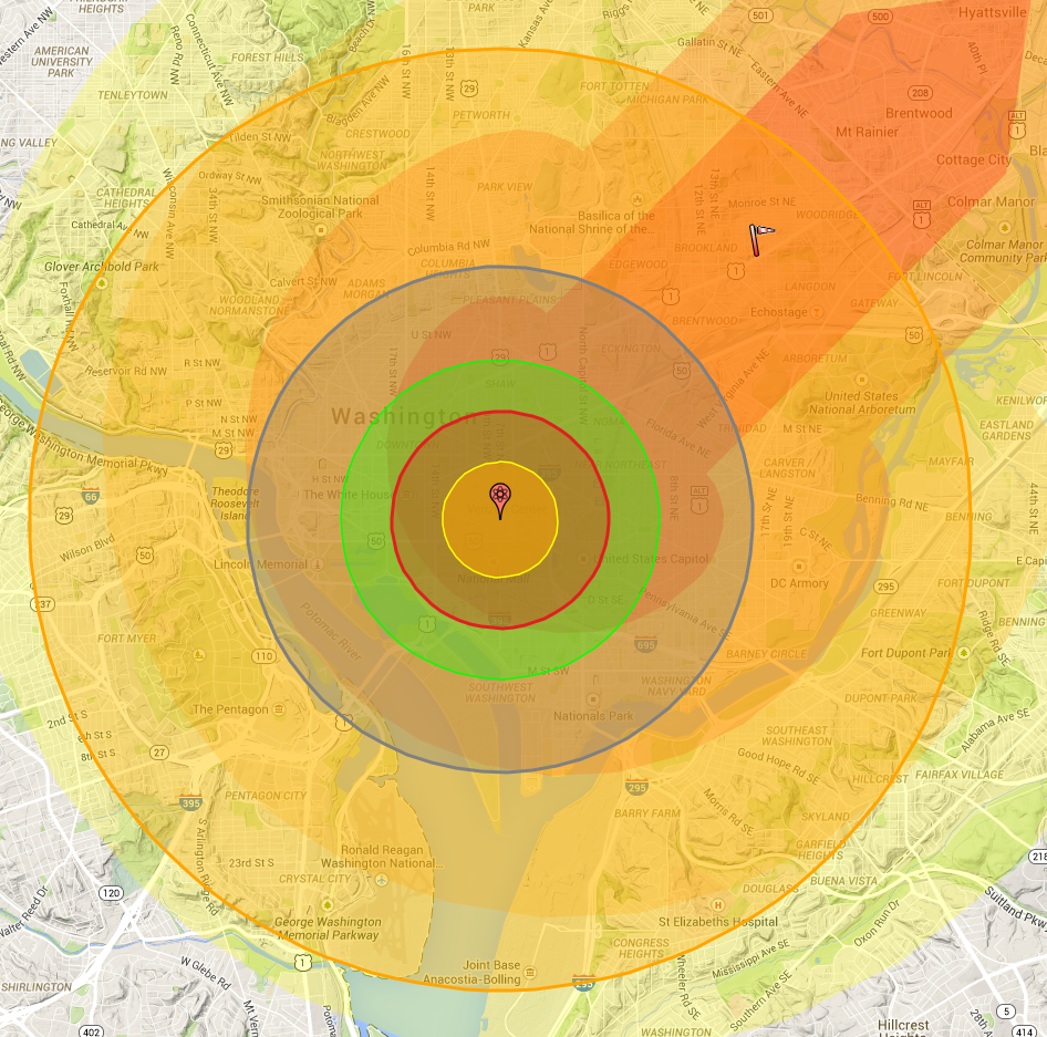
| 20 kilotons on Boston, viewed from airplane height | 20 kilotons on Washington, DC, viewed from airplane height | 20 kilotons on Washington, DC, viewed from the Library of Congress |
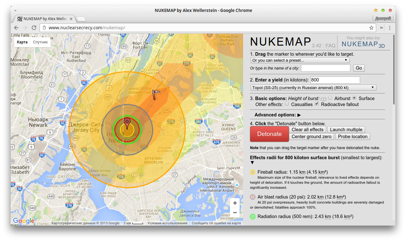
| 20 kilotons on downtown Manhattan, as viewed from the New York Academy of Medicine (upper east side), with the application interface visible | 800 kilotons on New York City, as viewed from airplane height at a substantial distance | 800 kilotons on New York City, as as viewed from Low Earth Orbit (i.e., the International Space Station) |
|
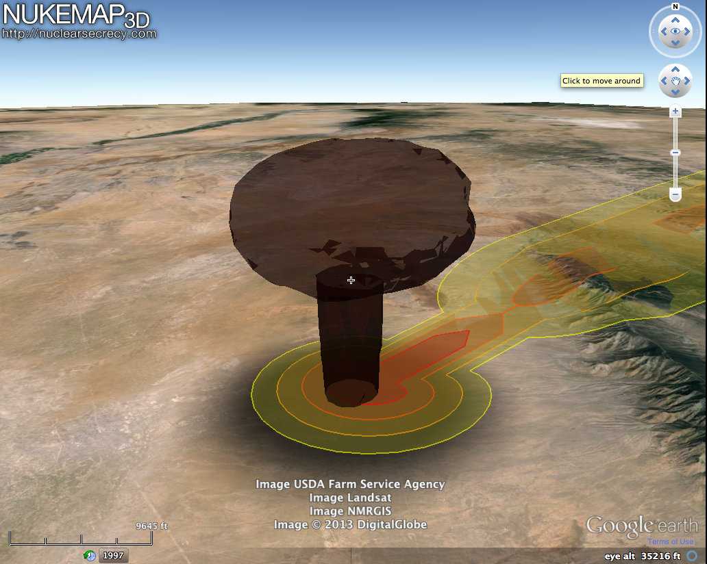
A very high yield detonation (I don’t remember the exact yield; probably at least 10 megatons), as seen from a very far distance, demonstrating both its great height but also how high yield detonations had extremely wide mushroom tops. One of my favorite demonstrations of NUKEMAP3D was to show that if atmospheric conditions were unrealistically clear, the mushroom cloud from a 1 megaton detonation in Washington, DC, would be visible from the torch in the Statue of Liberty. |
For more information about the creation of the code, see the NUKEMAP FAQ.
What is the future of the NUKEMAP3D code?
If a viable replacement for the Google Earth Browser Plugin becomes available, I will port the code over to it. Google Map’s WebGL codebase seems to support 3D buildings like the Google Earth Browser Plugin once did, but they have not opened the API up to developers. It is not clear they will (Google’s profit motivation largely has led to it kill such initiatives from what I can tell).
A NUKEMAP-VR project is currently under development at the Stevens Institute of Technology using the effects codes of NUKEMAP3D. It may be able to provide an interesting alternative to the browser plugin, though a VR application will (for the time being) be much more limited in terms of who can access it, and its ability to render cities. (Google has been developing a Google Earth VR API, but they have denied my application to develop on it, because they are interested primarily in video game developers at this point. Sigh.)
If you’re a software developer with other ideas or connections with companies who could facilitate further work on this, please feel free to get in touch with me. The closest thing out there to the Google Earth Browser Plugin is Cesium, but it doesn’t yet have global building support and so can’t really be used to give a sense of mushroom cloud scale.
This page was last updated in June 2019 by Alex Wellerstein.
Строим бункер сами запись закреплена
NukeMap 3D — Симулятор Ядерного Оружия
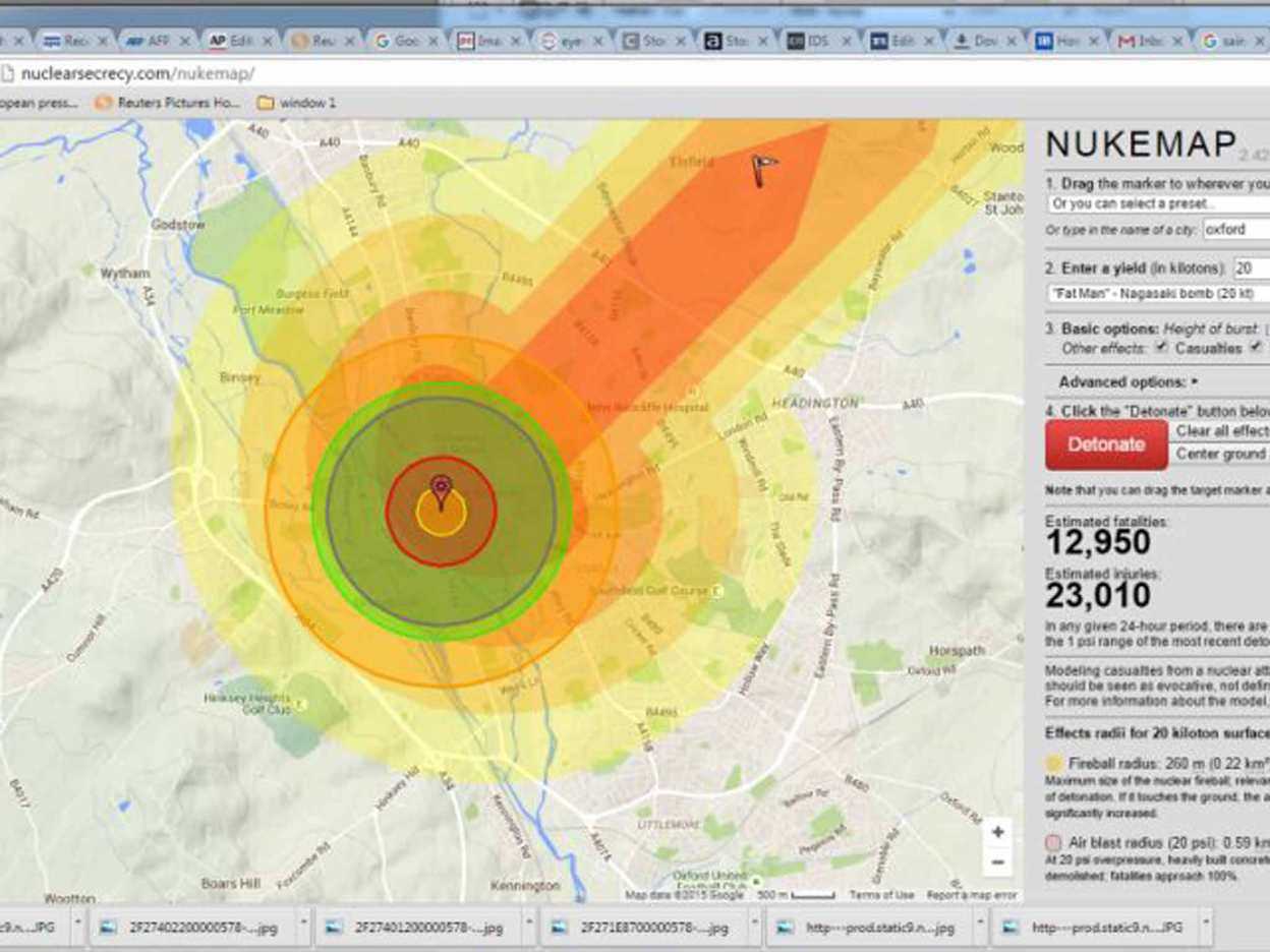
Ученый из Американского института физики, Алекс Веллерштейн, разработал симулятор ядерных взрывов Nukemap. Программа использует интернет-сервис Google Earth. В результате у него получилась интерактивная карта, наглядно моделирующая события, которые произойдут в случае сброса ядерной бомбы на любую территорию планеты.
При помощи сервиса »NukeMap 3D»,все желающие, установившие плагин для просмотра Google Earth, могут выбрать место взрыва, тип, мощность бомбы, также дополнительные эффекты при взрыве, а затем увидеть ее падение и разрастание облака. При этом предоставляется информация о площади поражения и числе жертв.
What is the future of the NUKEMAP3D code?
If a viable replacement for the Google Earth Browser Plugin becomes available, I will port the code over to it. Google Map’s WebGL codebase seems to support 3D buildings like the Google Earth Browser Plugin once did, but they have not opened the API up to developers. It is not clear they will (Google’s profit motivation largely has led to it kill such initiatives from what I can tell).
A NUKEMAP-VR project is currently under development at the Stevens Institute of Technology using the effects codes of NUKEMAP3D. It may be able to provide an interesting alternative to the browser plugin, though a VR application will (for the time being) be much more limited in terms of who can access it, and its ability to render cities. (Google has been developing a Google Earth VR API, but they have denied my application to develop on it, because they are interested primarily in video game developers at this point. Sigh.)
If you’re a software developer with other ideas or connections with companies who could facilitate further work on this, please feel free to get in touch with me. The closest thing out there to the Google Earth Browser Plugin is Cesium, but it doesn’t yet have global building support and so can’t really be used to give a sense of mushroom cloud scale.
This page was last updated in June 2019 by Alex Wellerstein.
What did NUKEMAP3D do and look like?
NUKEMAP3D was a mashup between the NUKEMAP and the Google Earth Browser Plugin, created by Alex Wellerstein in 2013. It allowed a user to see the ground effects of a nuclear weapon over any city in the world in 3D, as well as render a size-accurate mushroom cloud for any given yield of nuclear weapon. The goal was to help give a human understanding of nuclear weapons detonations: everyone has seen photographs of nuclear mushroom clouds, but few people have any sense of how large they actually are. Even a «small» nuclear weapon (by modern standards), like those used over the cities of Hiroshima and Nagasaki, is many times larger than anything human beings have ever built. By engaging the third dimension, something more intuitive triggers in the brain, even more so than the 2D representations possible in the original NUKEMAP.
Some screenshots from NUKEMAP3D have been preserved (click to see full-sized):
| 20 kilotons on Manhattan, viewed airplane height | 20 kilotons on mid-town Manhattan, as viewed from nearer to the surface, with the Statue of Liberty and downtown Manhattan for scale | 20 kilotons on Manhattan (animated GIF; you could have the cloud rise in real-time, which would take about 10 minutes) |
| 20 kilotons on Boston, viewed from airplane height | 20 kilotons on Washington, DC, viewed from airplane height | 20 kilotons on Washington, DC, viewed from the Library of Congress |
| 20 kilotons on downtown Manhattan, as viewed from the New York Academy of Medicine (upper east side), with the application interface visible | 800 kilotons on New York City, as viewed from airplane height at a substantial distance | 800 kilotons on New York City, as as viewed from Low Earth Orbit (i.e., the International Space Station) |
| A very high yield detonation (I don’t remember the exact yield; probably at least 10 megatons), as seen from a very far distance, demonstrating both its great height but also how high yield detonations had extremely wide mushroom tops. One of my favorite demonstrations of NUKEMAP3D was to show that if atmospheric conditions were unrealistically clear, the mushroom cloud from a 1 megaton detonation in Washington, DC, would be visible from the torch in the Statue of Liberty. |
For more information about the creation of the code, see the NUKEMAP FAQ.
What alternatives to NUKEMAP3D exist?
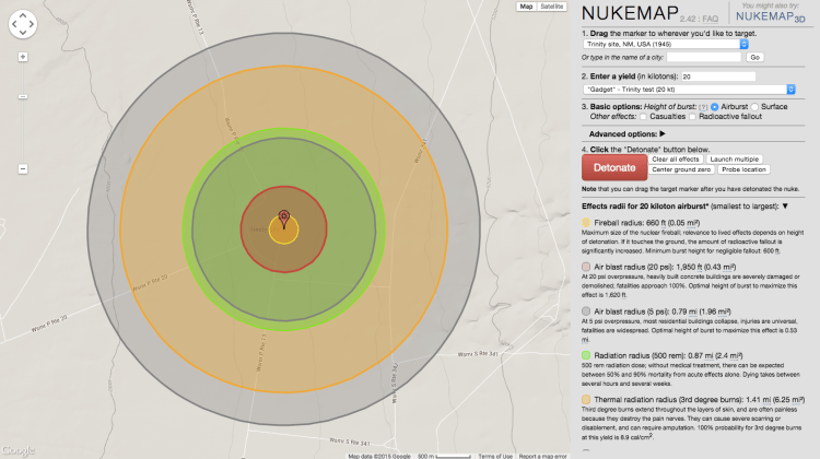
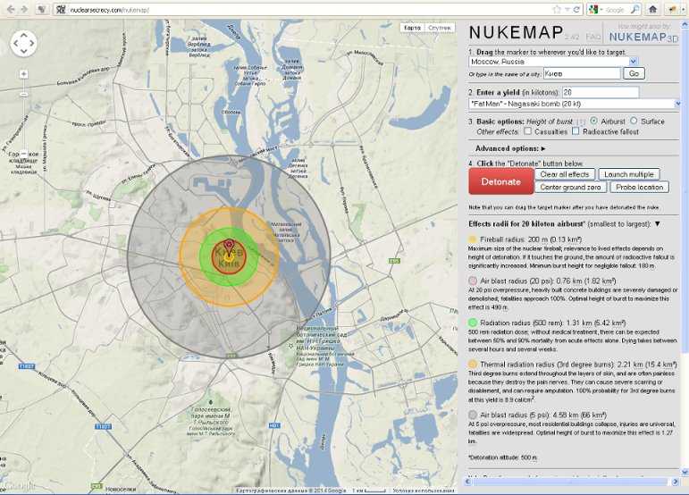
At the moment, the only easy alternative is to use the NUKEMAP’s experimental KMZ output option. To use it, set up any detonation(s) you want to view in 3D in NUKEMAP, and then, click on «Advanced Options»:
Scroll down to the end of the «Advanced Options» and you’ll find a link that says «Export to KMZ»:
Clicking that opens up the «Export to KMZ» options. There are a lot of options but you probably just want to leave the default ones and click «Download File.» But you’re welcome to experiment with the other options if it doesn’t look the way you’d like it to, or you want it to show fallout or the fireball.
Once you’ve download the KMZ file (named nukemap.kmz by default), you can then open it in the free Google Earth Pro desktop application:
As noted, this functionality is still experimental. It does not always reliably export fallout plumes, for example. And the Google Earth desktop application does not render buildings at the same distance as the plugin did, so it doesn’t quite give the same effect. Note that once it is in Google Earth Pro, you can toggle off the various components of the model as «layers» in the sidebar.